
By Cindy Brown
From alpine meadows to rushing creeks, these Taos-area trails offer something for every kind of hiker. With so many choices near Taos, how do you decide where to hike? Here are three fantastic places that provide jumping-off points for easier family outings, as well as more challenging routes for experienced hikers.
Columbine
Where to find it: North of Taos, east of Questa
Where to start: Hikes begin at Columbine Campground
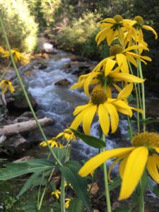
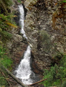
Family-friendly adventures: Head up Columbine Canyon Trail (Carson National Forest #71) as it follows Columbine Creek. A gradual climb meanders through aspen and alder. The trail crosses the creek several times and leads to a small meadow — a good place to end a short hike. Continue farther to reach a large meadow that makes a popular picnic spot. For added fun, try this hike with llamas; Wild Earth Llama Adventures: llamaadventures.com.
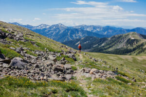
For more experienced hikers: Columbine Canyon Trail connects with Deer Creek, Placer Fork and Willow Fork trails, which head toward Gold Hill. Stay on the main trail as it steepens and climbs a series of switchbacks. In this section, the creek flows across moss-covered boulders, and in the summer, columbine and blue chiming bells bloom nearby. After a third meadow, the trail steepens again and climbs to the ridge at 11,800 feet. Here, the trail connects with Gavilan Canyon Trail, which descends toward Taos Ski Valley. This hike gains 3,800 feet and runs about 12 miles round trip.
Why we love it: Columbine Creek keeps the hike cool, and the overflow creates a perfect environment for wildflowers in July and August.
How to get there: From Taos Plaza, go north on Paseo del Pueblo, which becomes NM 522. Drive 24 miles to Questa and turn right at NM 38. Pass the Questa Ranger Station on the right. Near mile marker 5, turn right at the Columbine Campground entrance. Follow the one-way loop and go 0.5 miles to the trailhead across from the bathrooms.
Santa Barbara
Where to find it: South of Taos, near Peñasco
Where to start: Santa Barbara Campground
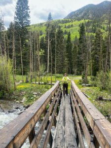
Family-friendly adventures: Set off from the campground on Santa Barbara Trail (CNF #24). The trail winds into the Pecos Wilderness, following the Rio Santa Barbara through conifer and aspen forests. It climbs gradually above the river, then drops to meet it again. Small meadows dot the route, and cattle may graze here at times. The trail crosses the river on a bridge, where the path begins to climb — a natural turnaround point for a shorter hike.
For more experienced hikers: The possibilities stretch far beyond the main trail. Watch for the West Fork Trail (CNF #25) sign and turn right. The trail climbs to a large meadow with views of Chimayosos Peak. Wildflowers and mushrooms often appear here in summer, and wildlife sightings may include wild turkeys or even a bobcat. This route connects to the Santa Barbara Divide and Truchas Lakes.
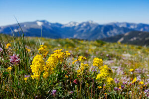
Why we love it: The Santa Barbara area shines in summer with abundant wildflowers and again in fall, when expansive aspen groves turn gold.
How to get there: From Taos Plaza, drive 3 miles south on Paseo del Pueblo and turn left on NM 518. Climb US Hill and continue 16 miles before turning right on NM 75. Follow the road through Vadito and past the Camino Real Ranger District office. Shortly after, turn left on NM 73. Drive 1.5 miles, then turn left onto Santa Barbara Road and continue 5.5 miles to the campground. Depending on the season, a parking fee may apply.
Taos Ski Valley
Where to find it: Northeast of Taos
Where to start: Taos Ski Valley base area
Family-friendly adventures: For a gentle walk along the Rio Hondo, try the JR Ramming Trail. The path begins near the Rio Hondo Children’s Learning Center and follows the river to the ski valley base area, where shops and restaurants await.
For more experienced hikers: A favorite route climbs Long Canyon to Gold Hill. Start east of the parking lot at the Bull-of-the-Woods/Wheeler Peak Trail (CNF #90). Climb about 1 mile to the Long Canyon (CNF #63) turn and go left. Follow the stream through the canyon, then climb toward Gold Hill (CNF #64). The hike starts at 9,400 feet and tops out at 12,700 feet, gaining 3,300 feet over about 9 miles. Start early and leave exposed ridges if afternoon storms build.
Why we love it: Along the Rio Hondo and its East Fork, columbine, wild geranium and other wildflowers bloom in July and August. At 9,400 feet, Taos Ski Valley stays cool in summer.
How to get there: From Taos Plaza, go north on Paseo del Pueblo about 4 miles. Turn right on NM 150, the ski valley road. Drive through Arroyo Seco and bear left at the old school. Continue to Taos Ski Valley. For the JR Ramming Trail, turn right toward the Children’s Center. For Bull-of-the-Woods, stay left to the upper parking lot. The trailhead sits on the left (northeast) side.